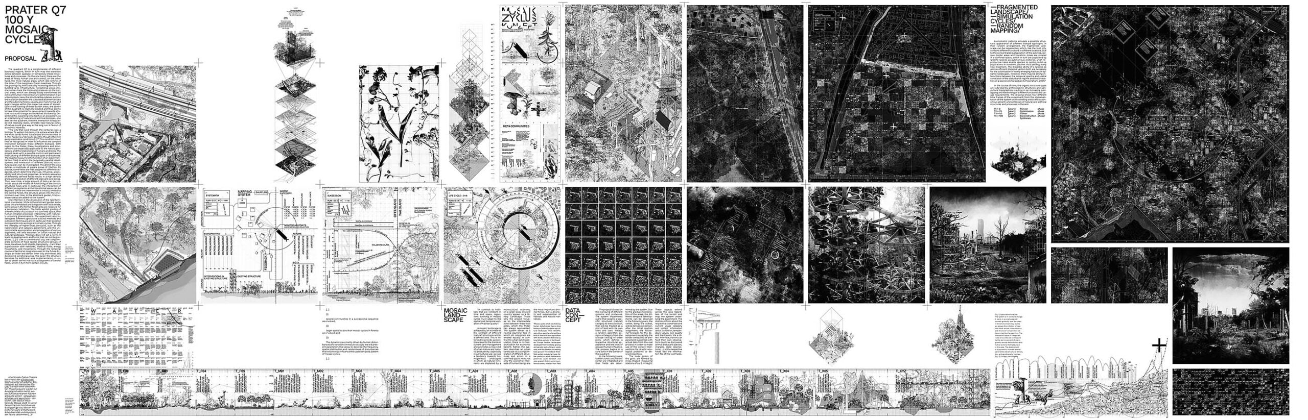
A 100 year successional
forest city experiment

Das Entwurfsprojekt entstand 2018 im GLC-Studio unter der Leitung von Sandra Bartoli und Daniela Herold mit dem Titel “In the Beginning and End, There Was Prater — The City’s Future Natural History”. Es umfasste Forschung und Kartierung von neun Praterquadranten, Exkursionen mit Experten sowie die Entwicklung von Hypothesen zur zukünftigen Naturgeschichte des Praters im Anthropozän. Ausgehend vom Studio-Brief “Prater IS city. Prater is the most public open space…” wurde der Prater nicht nur als Grünraum, sondern als urbanes Gefüge betrachtet, in dem Pflanzen, Tiere und Menschen interagieren. Das Projekt konzentriert sich auf den unscheinbaren Kartierungsquadranten Q7 im Südosten nahe dem Lusthaus am Ende der Praterallee. Ein zentrales Waldareal wird vom Heustadelwasser, einem abgeschnittenem Donau Altarm, Bahngleisen und einer Kleingartenkolonie eingefasst. Eine Kartierung (M 1:500) erfasste Artefakte, Pfade, Vegetationsstrukturen und technische Relikte, die zunehmend von Wildwuchs überlagert werden. Daraus entstanden drei ortsspezifische Leitmotive:
Garden—Grenze zwischen Kleingärten und Praterwald,
Forest—Trampelpfad entlang des Bahnwalls und
Water —das regulierte Heustadelwasser.
Diese Themen reflektieren das Spannungsfeld zwischen Stadt und wilder Natur und wurden in isometrischen Ansichten dargestellt.
Im zweiten Teil wurde die Geschichte der kleinräumigen Biotope und Randzonen experimentell weitergedacht. Ein 25x25m-Raster mit vernetzten Sensoren definierte per Algorithmus zufällig künftige Nutzungen und Naturräume. So entstand ein sich zyklisch wandelndes Mosaik, in dem besonders die entstehenden Übergangszonen – sogenannte Ökotone – untersucht wurden, da sie durch Artenreichtum und ökologische Dynamik geprägt sind. Das Experiment analysierte sukzessive Übergänge von Offenland zu Wald sowie die parallele Entwicklung urbaner und agrarischer Praktiken. Anfangs wurden einzelne Flächen minimal verändert – etwa durch Lichtungen oder Hütten –, doch mit der Zeit verdichtete sich der Praterquadrant durch wachsende Biomasse, Bauwerke und Artenvielfalt.
Das Projekt versteht den Prater als Modellraum, in dem Stadt und Natur nicht als Gegensätze, sondern als koexistierendes Gefüge betrachtet werden. Die Arbeit plädiert für eine ökologische Perspektive auf Stadtplanung – ein essenzieller Fokus angesichts von Klima- und Biodiversitätskrisen. Architektur kann nicht mehr losgelöst von der Natur gedacht werden, sondern als Verflechtung verschiedener Spezies, Materialien und Zeitebenen. Orte wie die Wildnis des Praters haben immense Bedeutung für die Stadt. Architektur kann hier bestehende Strukturen sichtbar machen, verborgene Nischen beleuchten und fragile Biotope schützen. Die Methodik des Studios mit Exkursionen, Kartierungen und sensiblen Beobachtungen, hat meine Sichtweise auf Architektur nachhaltig geprägt und floss in meine folgenden Projekte ein. Ich hoffe, die Arbeit regt dazu an, den scheinbaren Widerspruch zwischen Natur und Kultur zu hinterfragen und die verborgenen Potenziale urbaner Zwischenräume neu zu entdecken.
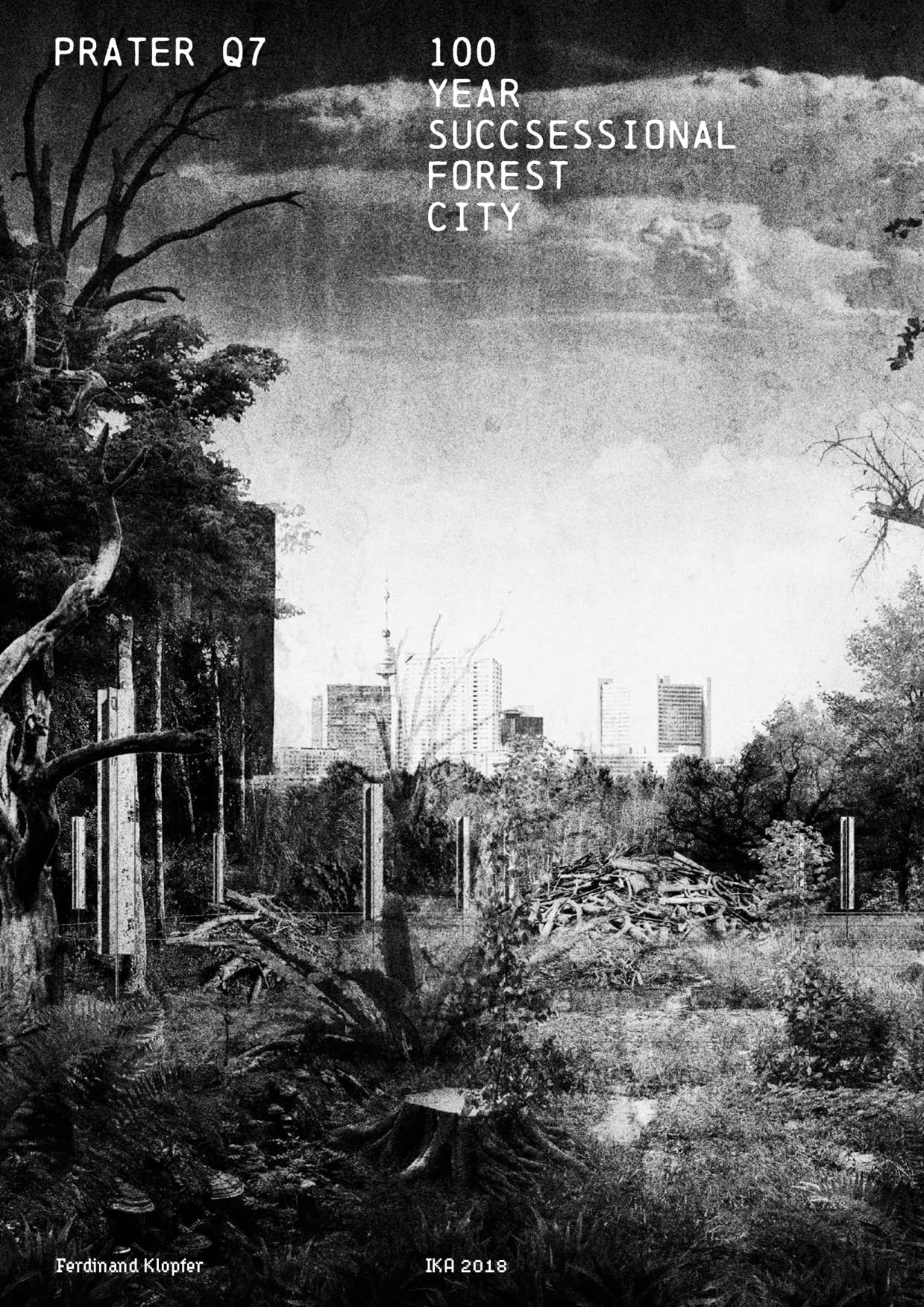
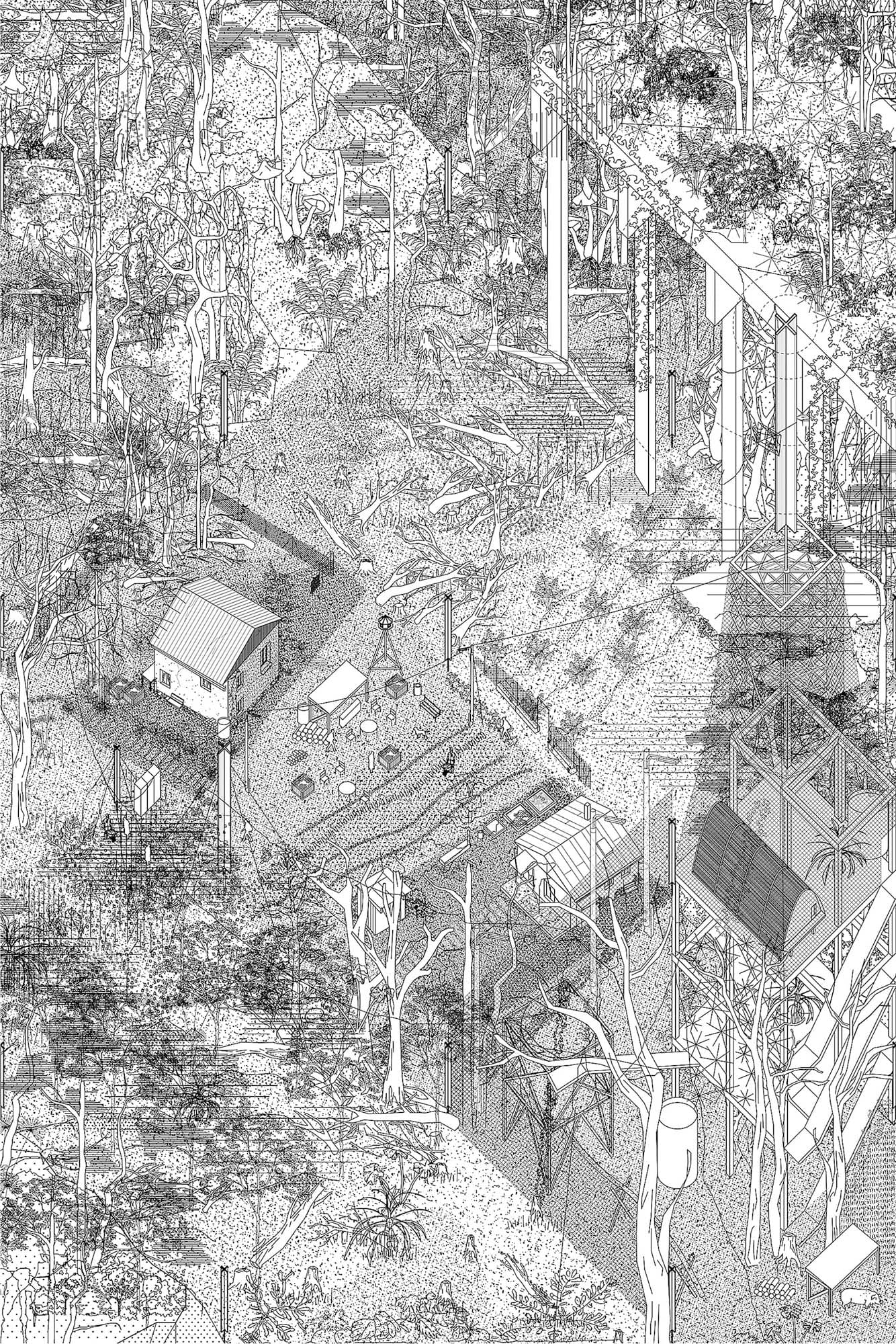
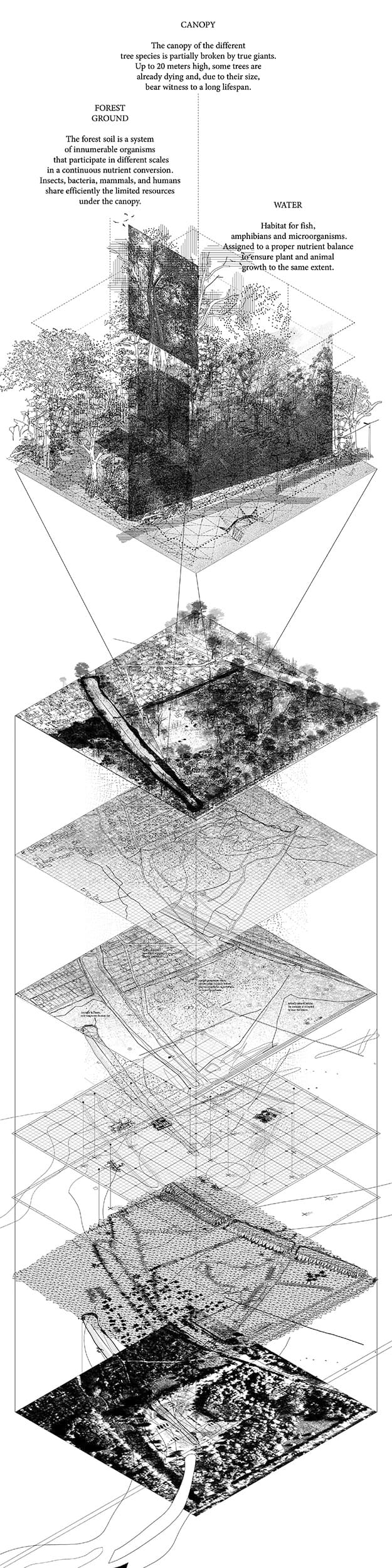
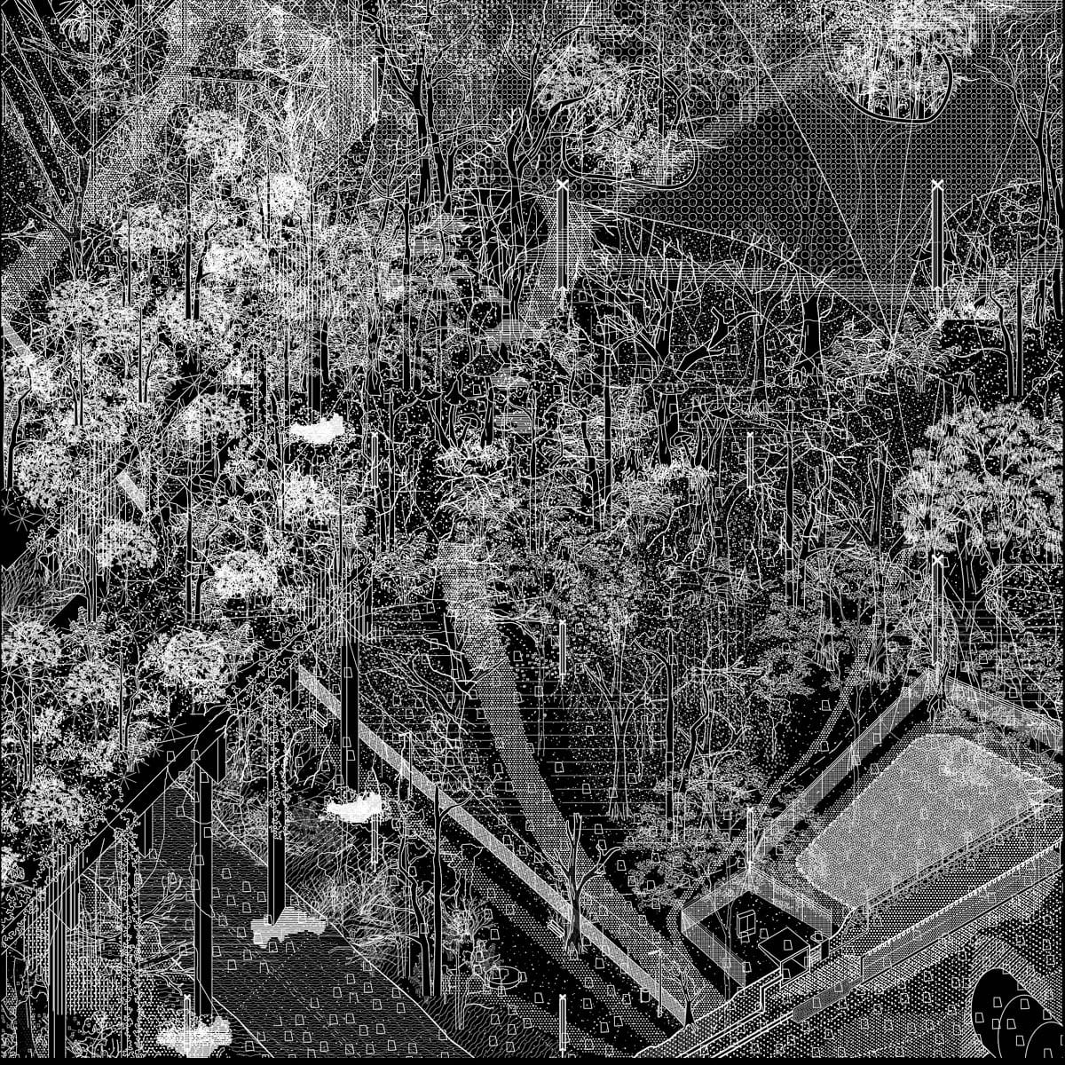
Das Projekt untersucht den zunächst unscheinbaren Kartierungsquadrant Q7 im südöstlichen Teil des grünen Praters in der Nähe des Lusthauses, der gleichwohl das Spektrum von gebauter Stadt zu natürlicher Au-Wildnis abbildet. Das Gebiet ist durch einen zentralen Waldbereich gekennzeichnet, der nach allen Seiten durch unterschiedliche Elemente abgegrenzt ist. In Richtung Praterstern trennt das Heustadelwasser, ein abgetrennter Altarm der Donau, die Flächen beiderseits der Hauptallee und reicht im Norden bis in die heute dauerhaft bewohnte Kleingartenkolonie, im Osten erhebt sich ein künstlicher Wall mit Bahngleisen. Eine Kartierung in 1:500 verortet Fundstellen von menschlichen Artefakten, Spuren der ursprünglichen Aulandschaft, Tier- und Menschenpfade und Vegetationsstrukturen, sowie seltsame technische Anlagen und Bauwerke, die zunehmend von Wildwuchs überwuchert werden. Aus der Kartierung entwickelten sich die drei ortsspezifischen Leitmotive des Quadranten: Garden (Grenzlinie zwischen Kleingartenkolonie und Praterwald), Forest (ein verborgener Trampelpfad entlang des Bahnwalls) und Water (Der Altarm Heustadelwasser, dessen Wasser künstlich aufbereitet werden muss).
Diese Motive sind Indikatoren für das seltsame Verhältnis zwischen Mensch, Stadt und wilder Natur des Praters und sind jeweils in detaillierten isometrischen Ansichten dargestellt.
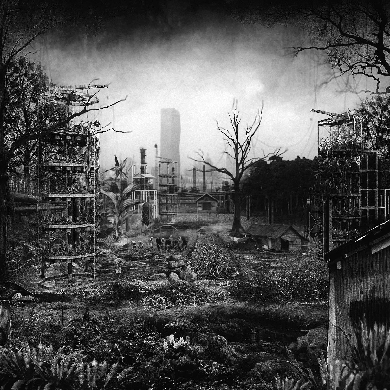
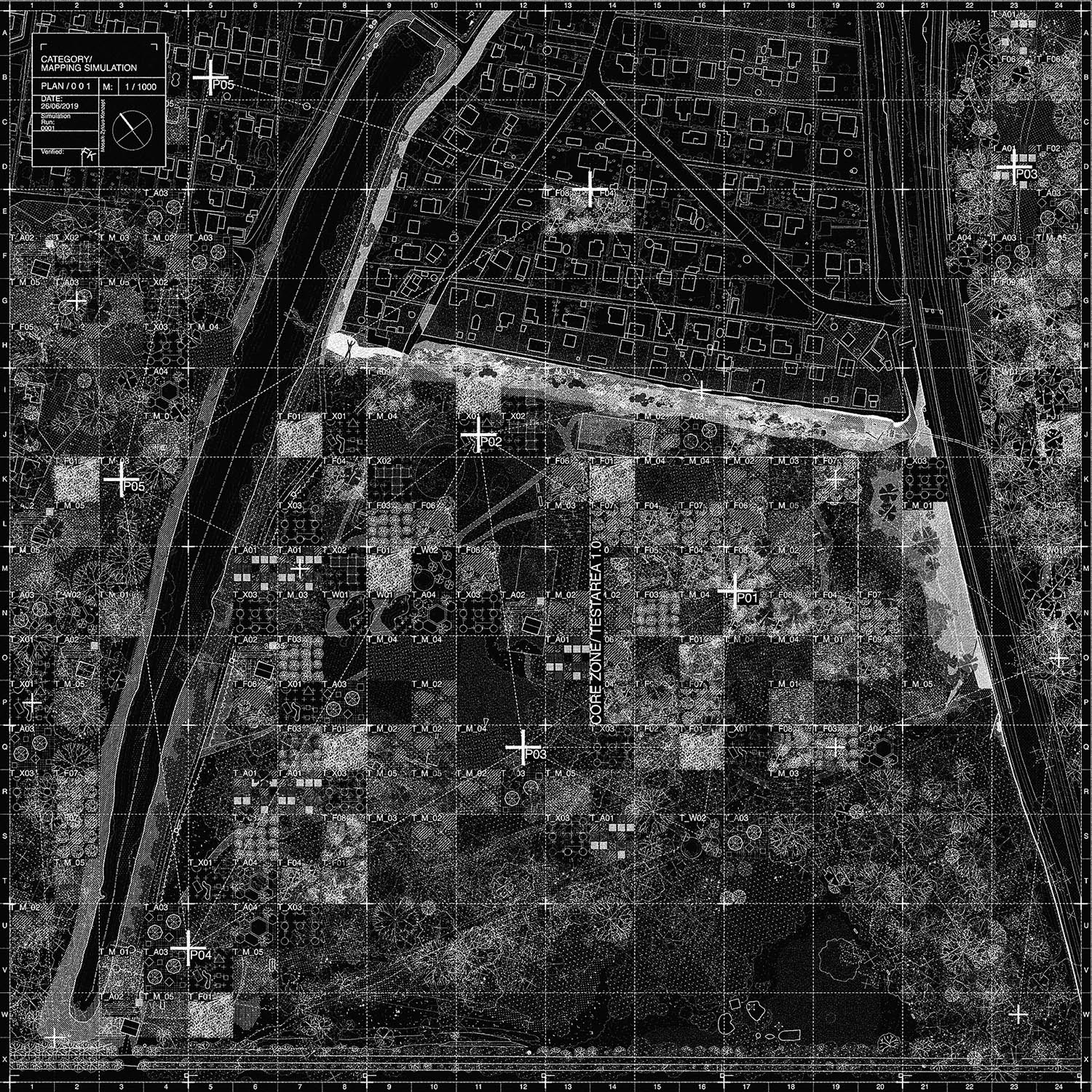
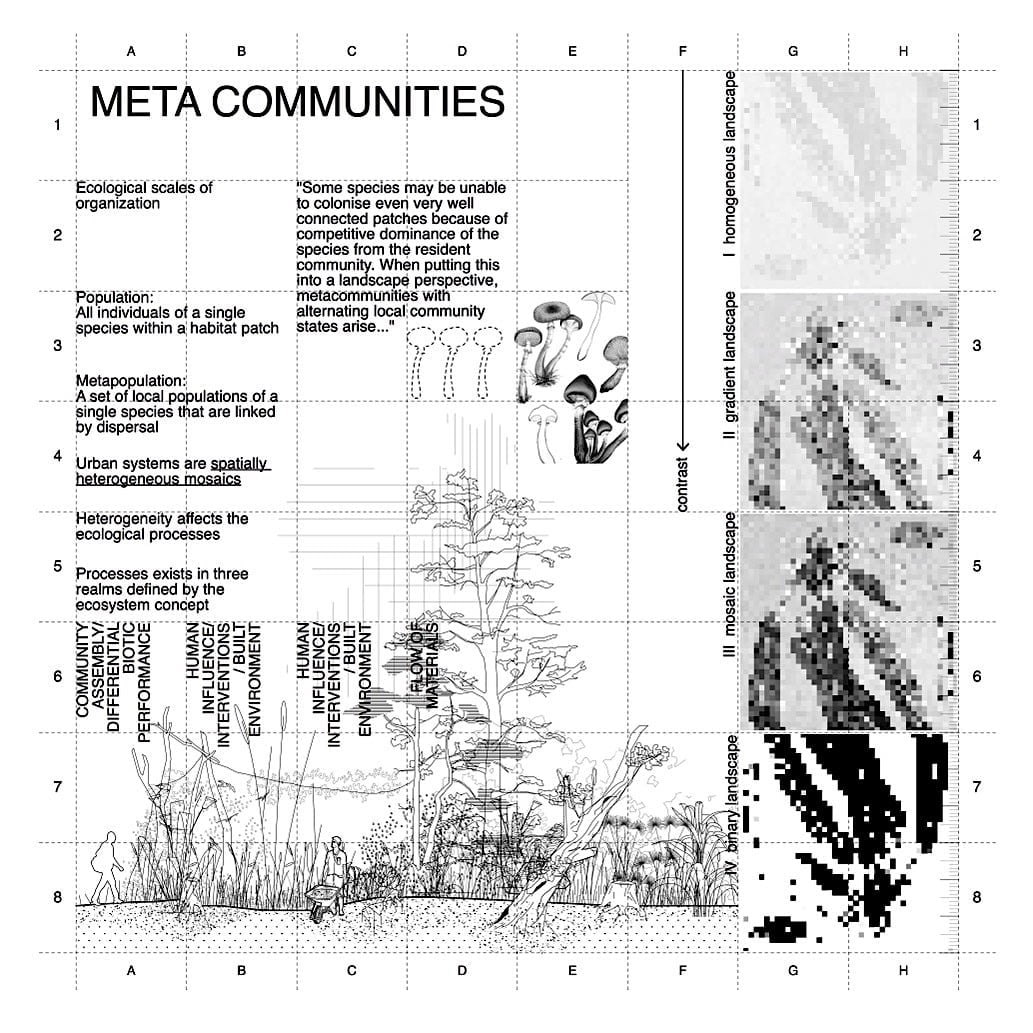
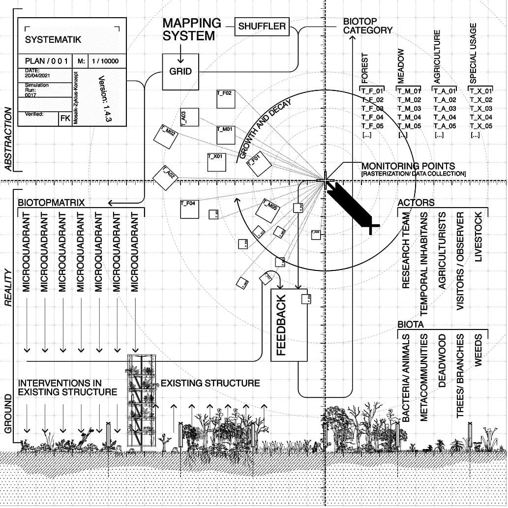
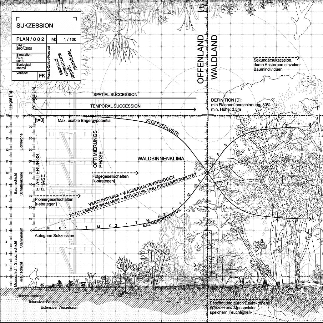
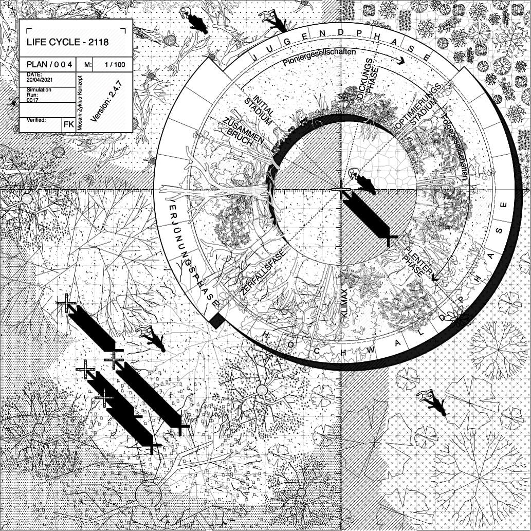
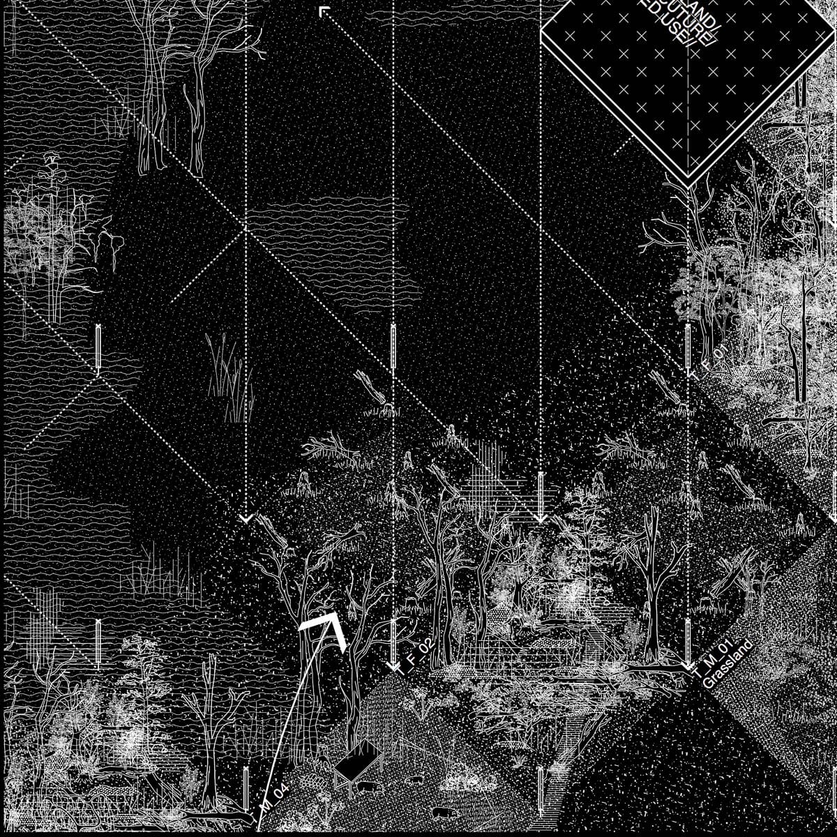
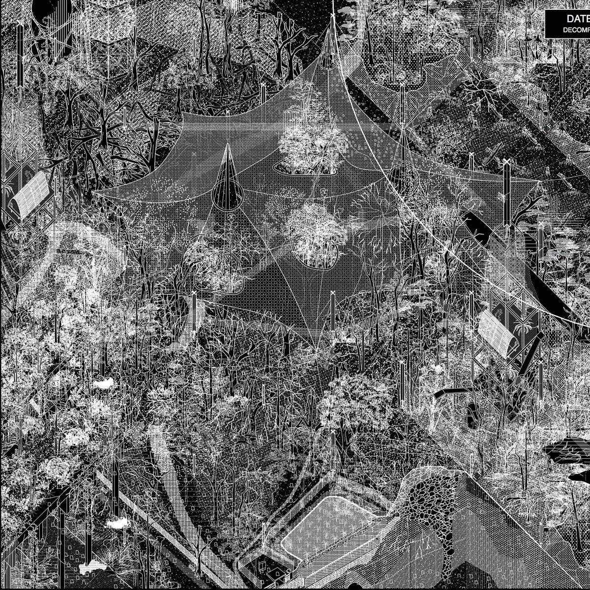
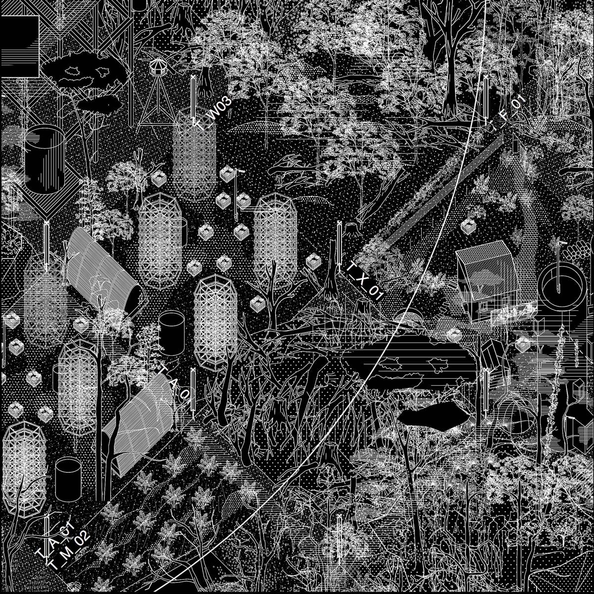
Im zweiten Teil des Projektes wird die Geschichte dieses Ortes der kleinräumigen Biotope, Randzonen und „Mikronarrative“ in Form eines räumlichen Experimentes weitergedacht und in der Intensität gesteigert. Dazu wird das Gebiet zunächst in ein Raster von 25x25m unterteilt (Kreuzförmige Stehlen markieren die Eckpunkte und dienen der Vernetzung von Sensoren und Datenquellen), wobei ein Algorithmus die zukünftigen Nutzungen und Naturräume randomisiert definiert. Durch die zunächst zufällige Zuweisung von Naturraum- und Nutzungstypus der einzelnen Felder entsteht ein diverses Mosaik, das sich zyklisch erweitert und verfeinert. Interessant sind dabei nicht nur die Einzelflächen selbst sondern insbesondere die neu entstehenden Rand- und Übergangsbereiche, denn speziell diese Zwischenräume ermöglichen Habitate und sind charakteristisch für den Grünen Prater. Ökologisch betrachtet bezeichnet man solche Zonen auch als Ökotone – die liminalen Räume zwischen zwei räumlichen Zuständen – die häufig durch ihren Artenreichtum herausstechen. Das Experiment untersucht somit ökologische Parameter wie die Stufen der Sukzession – sprich die Übergangsstadien von Grass- und Offenland hin zum Wald sowie parallel dazu die Sukzession der Stadt mit alternativen landwirtschaftlichen Praktiken und ruralen Wohnexperimenten.
Im Szenario beginnt das Experiment zunächst mit der leichten Umgestaltung einzelner Felder – wie das Schlagen einer Lichtung oder der Bau einer Hütte – doch mit den Jahren werden immer mehr Flächen integriert, bespielt, auf ihre ökologische Entwicklung hin erforscht und die Erkenntnisse wiederum in den Algorithmus eingespeist. Menschliche Interventionen und Bauwerke nehmen wie die Biomasse und die beheimateten Tier- und Pflanzenarten stetig zu – der Praterquadrant wird wie die Stadt selbst eine Verdichtung von Geschichten, Materie, Interaktionen und Metabolismen, die sich auf einen unvermeidbaren Klimax mit darauf folgender Zerfallsphase zuspitzen. Der Prater wird ein Modell in dem der Antagonismus zwischen Stadt und Natur aufgelöst werden soll, indem menschliche und nichtmenschliche Lebewesen als gleichwertig, voneinander abhängig und in Koexistenz betrachtet werden.
Die Arbeit untersucht die Stadt im ökologischen Kontext, der im Angesicht zunehmender Klima- und Biodivärsitäskrisen ein unerlässlicher Schwerpunkt in der Architekturausbildung werden sollte – Architektur kann heute nicht mehr als außerhalb der Natur gedacht werden, sondern immer als Entanglement (Verflechtung) von verschiedenen Spezies, Materien, Zeiträumen und Narrativen. Seltsame Zwischenorte wie die Wildnis des Praters haben einen unglaublichen Wert für die Stadt — Architektur kann hier den Fokus auf das setzten was bereits existiert und mit ihren Werkzeugen verborgene Nischen beleuchten und (Natur-)Geschichten sichtbar machen, weiterdenken und letztendlich die fragilen Biotope schützen, die eine Stadt erst zu einem Lebensraum machen. Die Perspektive des Designstudios auf die Umwelt der Stadt und die Methodiken mit Exkursionen, Kartierung, Theorie und sensiblen Beobachtungen on site, haben meine persönliche Einstellung zur Architekturpraxis stark geprägt, und sich thematisch in den darauffolgenden Entwurfsprojekten fortgesetzt und vertieft. Ich hoffe, dass die Arbeit dazu einlädt den scheinbaren Antagonismus zwischen Natur und Kultur zu hinterfragen, und den Blick für die verborgenen Lebenswelten und Potenzialen in den Zwischenräumen der Stadt zu schärfen.


Site Inspection / Research / Mapping
Photos

Mapping
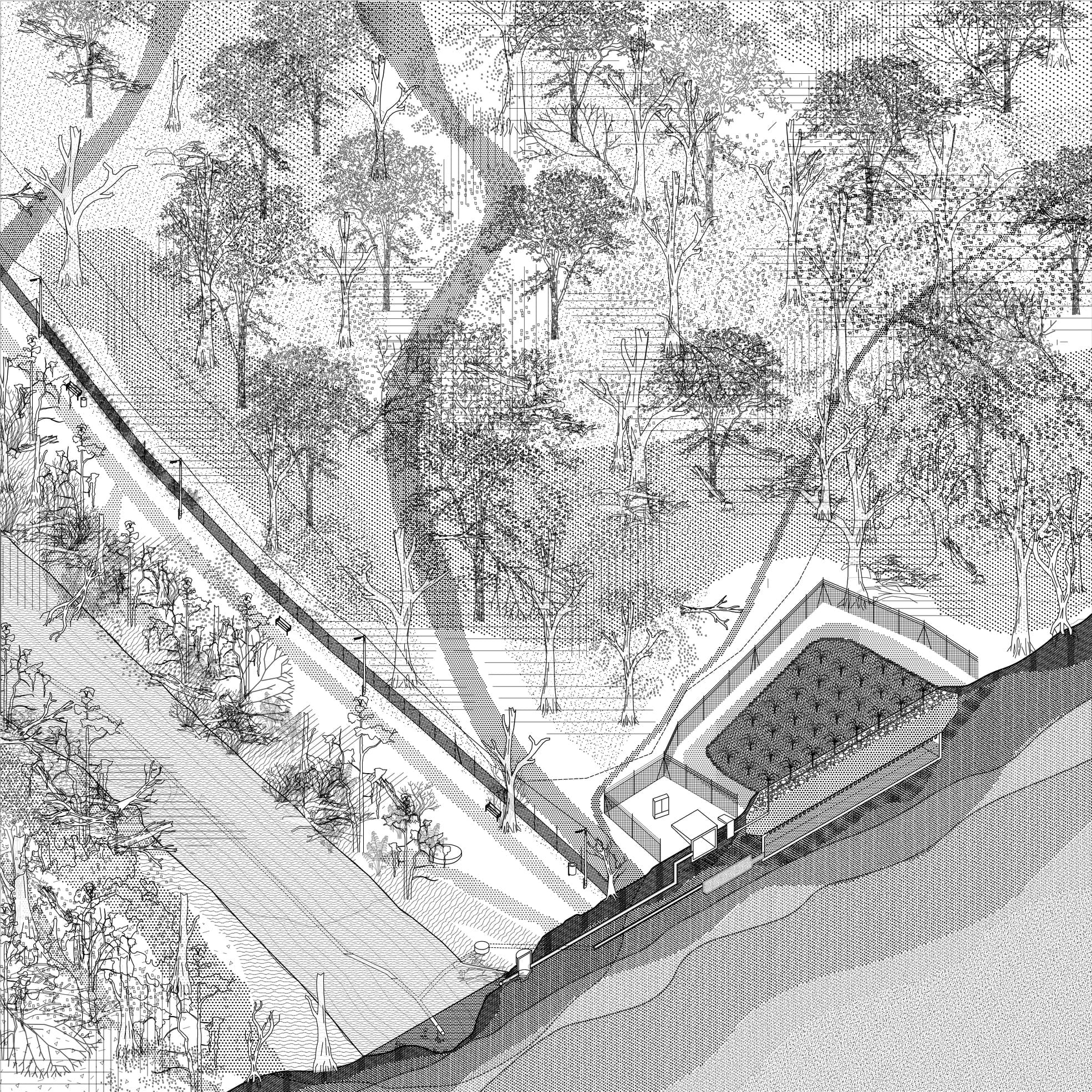
The mapping section Q7 is located on the southeastern part of the green Prater, near the Lusthaus. The area is characterised by a central forest area that is demarcated on all sides by different structural elements. In the direction of Praterstern, the Heustadelwasser, an old side river of the Danube, divides the areas on both sides of the main avenue and reaches up inside the allotment garden area, with permanently inhabited houses nowadays. A trench along the narrow street on the southern side of the “Kleingarten Verein Unteres Heustadlwasser” acts as the border between »wild and »cultivated nature and reaches up to a raised railway wall, which breaks through the forest to the south-eastern side. In the centre of the area, there is an equestrian facility with several paddocks and obstacles on the so-called Ameiswiese and bridle paths with obstacles that run through the forest. Since this area is partly fenced, it is not clear if it is private or public ground. At the southern Side, a meadow with benches and playgrounds closes up to the Hauptallee and has the highest level of human occupation in the inner forest sphere. The area shows, through its versatile uses and topographic conditions, how different levels of habitations in the Prater superimpose and interact. At the fringes, the pressure of usage builds up on the leftover natural areas, while at present, artificial interventions can open up an ecological niche for certain species. Starting from the researched areas that emerge from a special representation or opposing positions in the quadrant, we created isometric drawings that are meant to represent a particular situation with the collected information: 1 GARDEN Isolated realms and idealized nature 2 FOREST Crossing paths in the woods 3 WATER Life cycles and stagnation
Axonometrie Hauptmotive
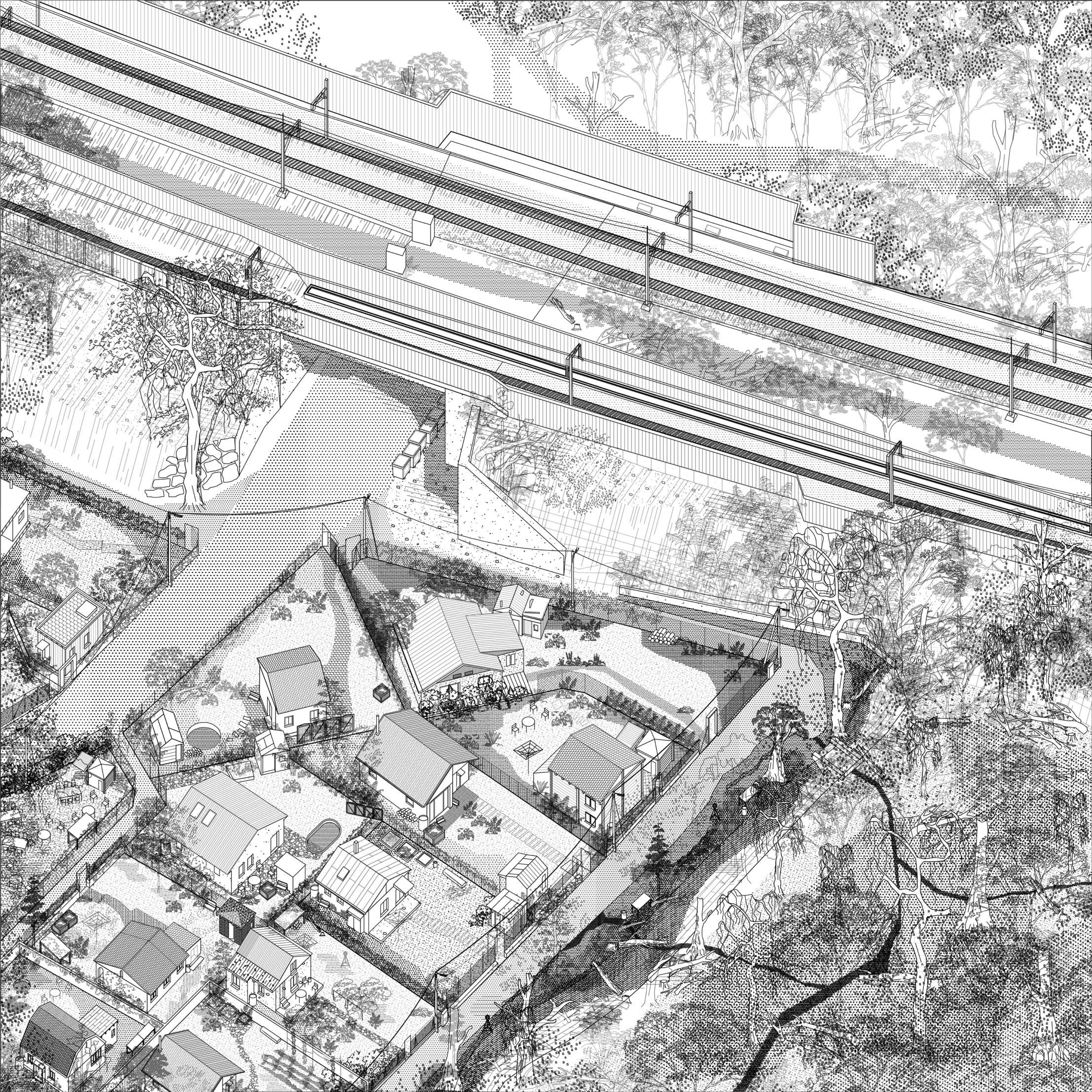
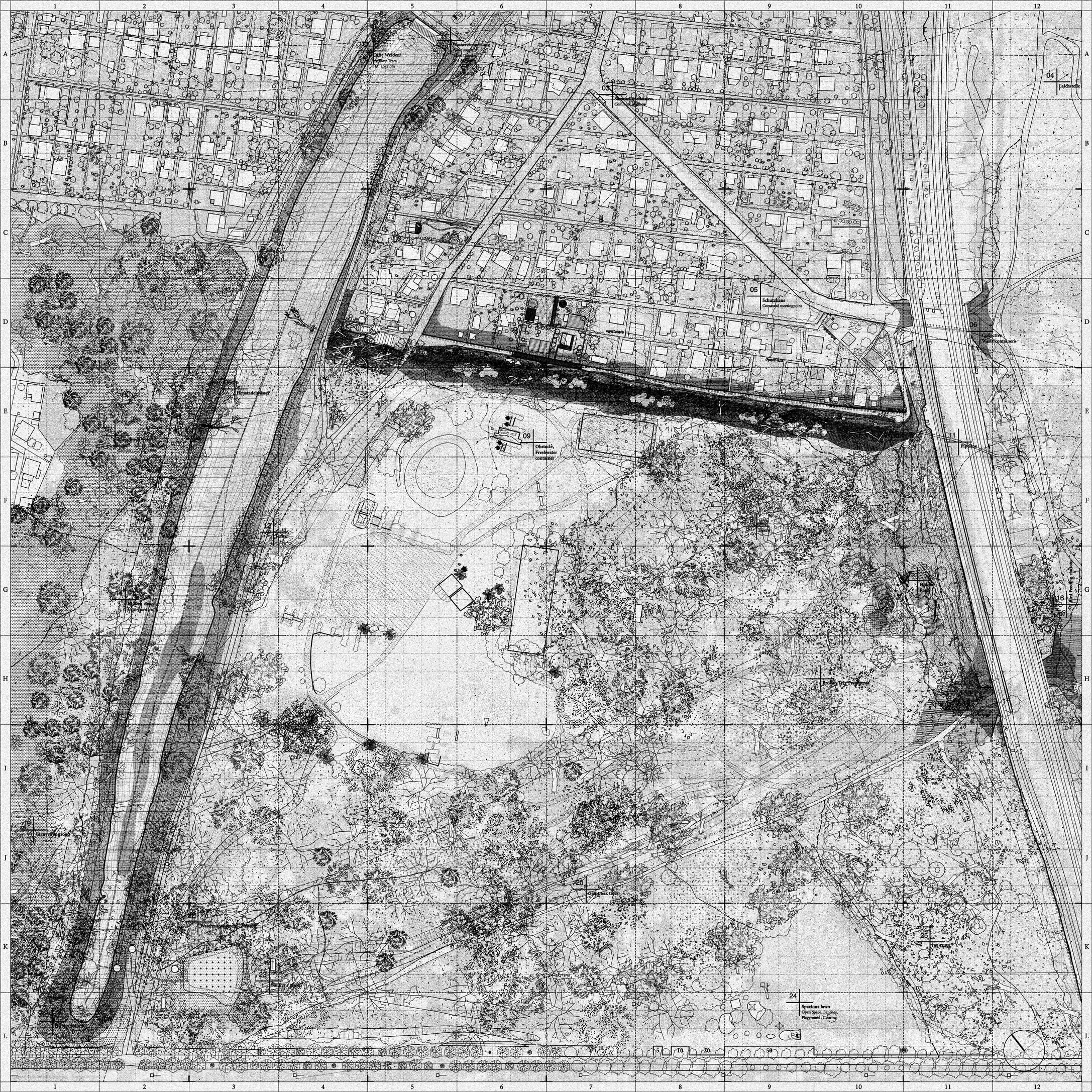
Allotment Garden Division and Colonisation
This drawing sets focus on the spot where the cultivated, the natural, and the infrastructural realm come together in a strange environment and define the occupied ground in their particular sense. The neutral view from above reveals an administrative system, which defines certain areas for a certain purpose (like housing areas, industrial and agricultural space, and protected natural habitats). Yet the division of di”erent surfaces seems to be realized artificially at first glance (through building, cultivating natural areas, or prohibition of building construction). But in detail, there is a constant overlapping of natural and cultural actions that overlay notional boundaries, like property borders and fences. The historical meaning of allotment gardens, as a space for food production and agricultural practice, disappears more and more. The transformation to a living area embedded in a decorative garden leads to a heavy control over every part of the area. At the transition zone, the inhabitants are defending their realm by decorating and colonizing undefined land around the ditch.
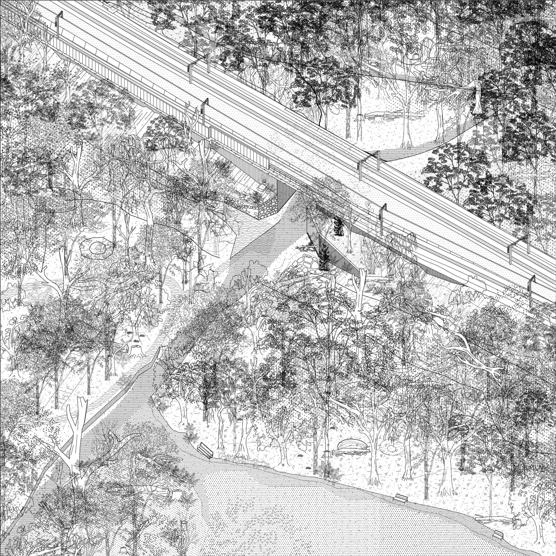
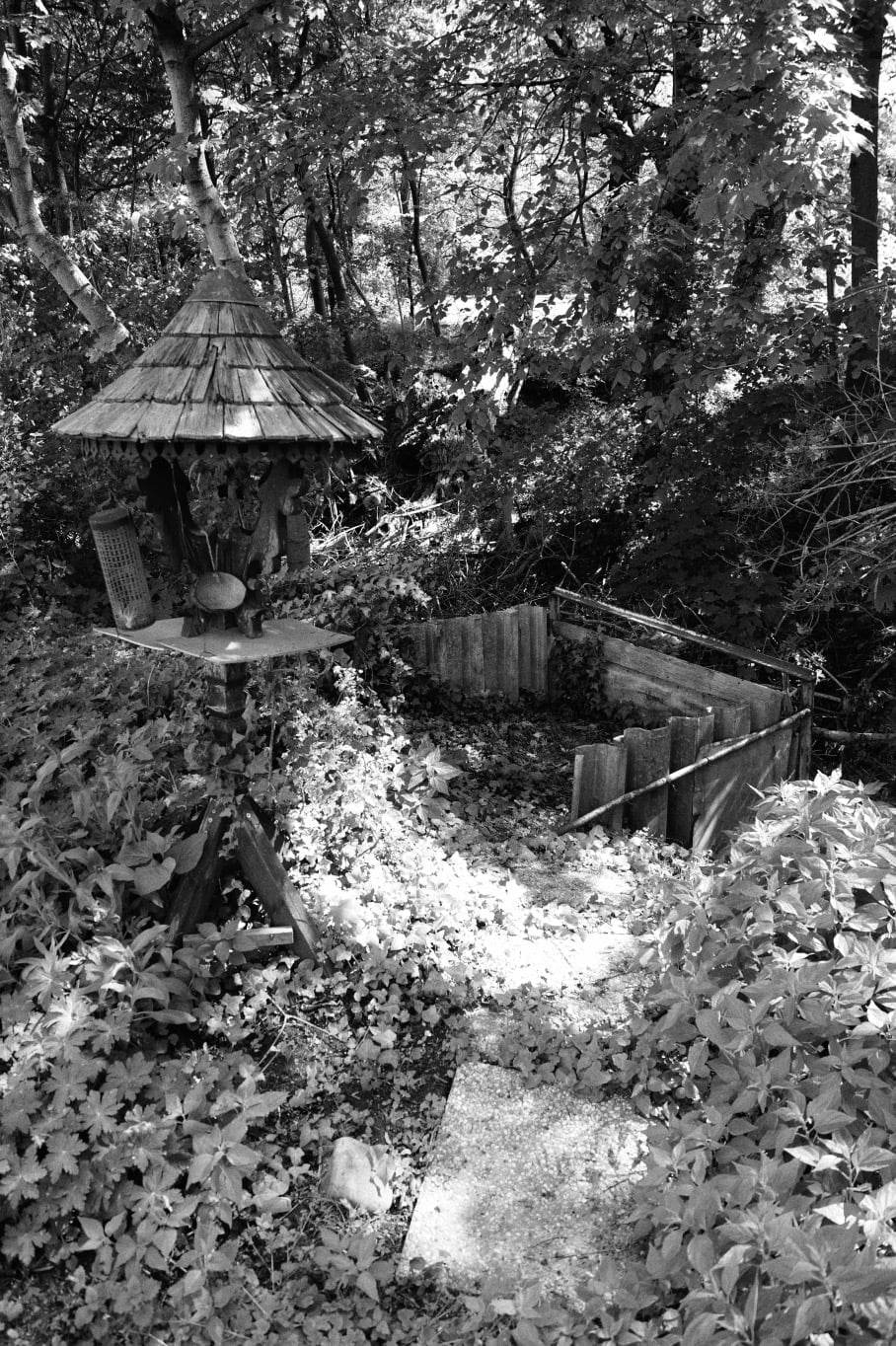
Hidden Paths
Crossing, Hideouts, Bomb craters
The right flank of the area is formed by a railway wall, which divides the forest and protrudes up to 6m above the ground. At this point, a concrete underpass has broken the wall, making it an important passageway for humans and animals: the city hiking trail and the extension of the riding route lead through the passage. Along the wall, a hidden path meanders through the wilder part of the forest area to the gardens. The informal path is often obstructed by fallen trees and wild growth and is used by only a few people. Nevertheless, some artefacts reminding of human presence can be discovered along the way. Scattered objects, like metal goods, concrete blocks, and rubbish, can be found there as well as birdhouses and feeding stations. Since this part of the forest is a protected refuge in the bustling Prater area, a small group of deer can be observed there many times. A wooden feeding trough reminds at a time when deer were fed around the Heustadelwasser, which leads to its name.
Heustadelwasser
Relict of the old Danube
Due to the Danube regulation, the Heustadelwasser was separated from the main river. This cut had a major impact on the ecological relations of flora and fauna and the whole appearance of the Prater. This former arm of the river delta, yet stagnant water, was only connected by ground water, which had been disconnected after the hydro power plant Freudenau was built in 1998. Without its annual floods and the higher phosphorus content from the main river, the Heustadelwasser is low in oxygen. This oversupply of nutrients causes an increased growth of algae, a decrease of natural habitats for amphibians, an ecological deficit and a higher fish mortality. To remedy such result the Heustadelwasser is filtered by a so-called „Neptun“ facility, which enhances the water quality through an emission of carbon dioxide and nitrogen and an enrichment of oxygen by irrigation. This water seeps through a layer of sediments and is brought back after the phosphorous amount is decreased. In particularly warm summers, the „Naptune“ facility cannot prevent the algea bloom, which also causes unpleasant odours and turbid water.

Proposal / Experiment
Experimental Mapping
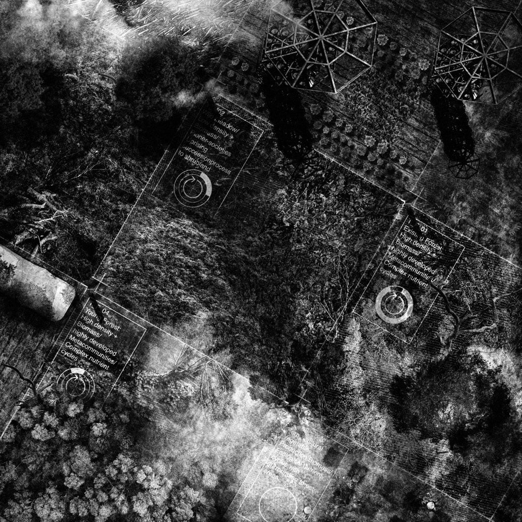
Mosaic Principles
Setion
Axonometric Mapping
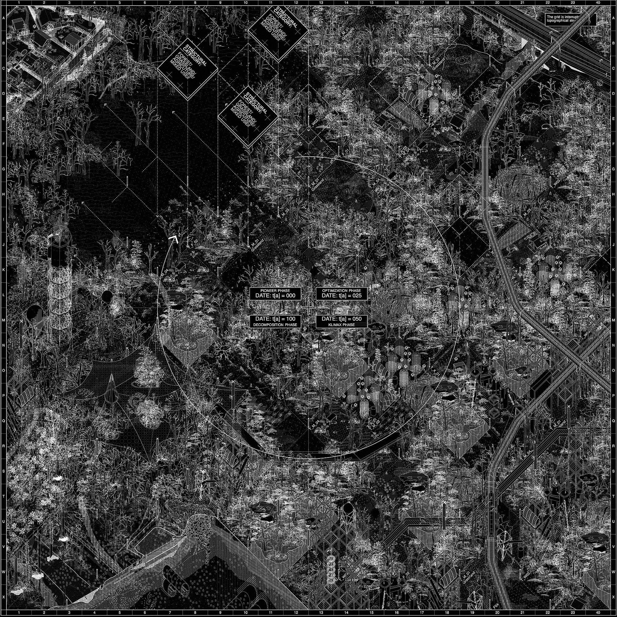

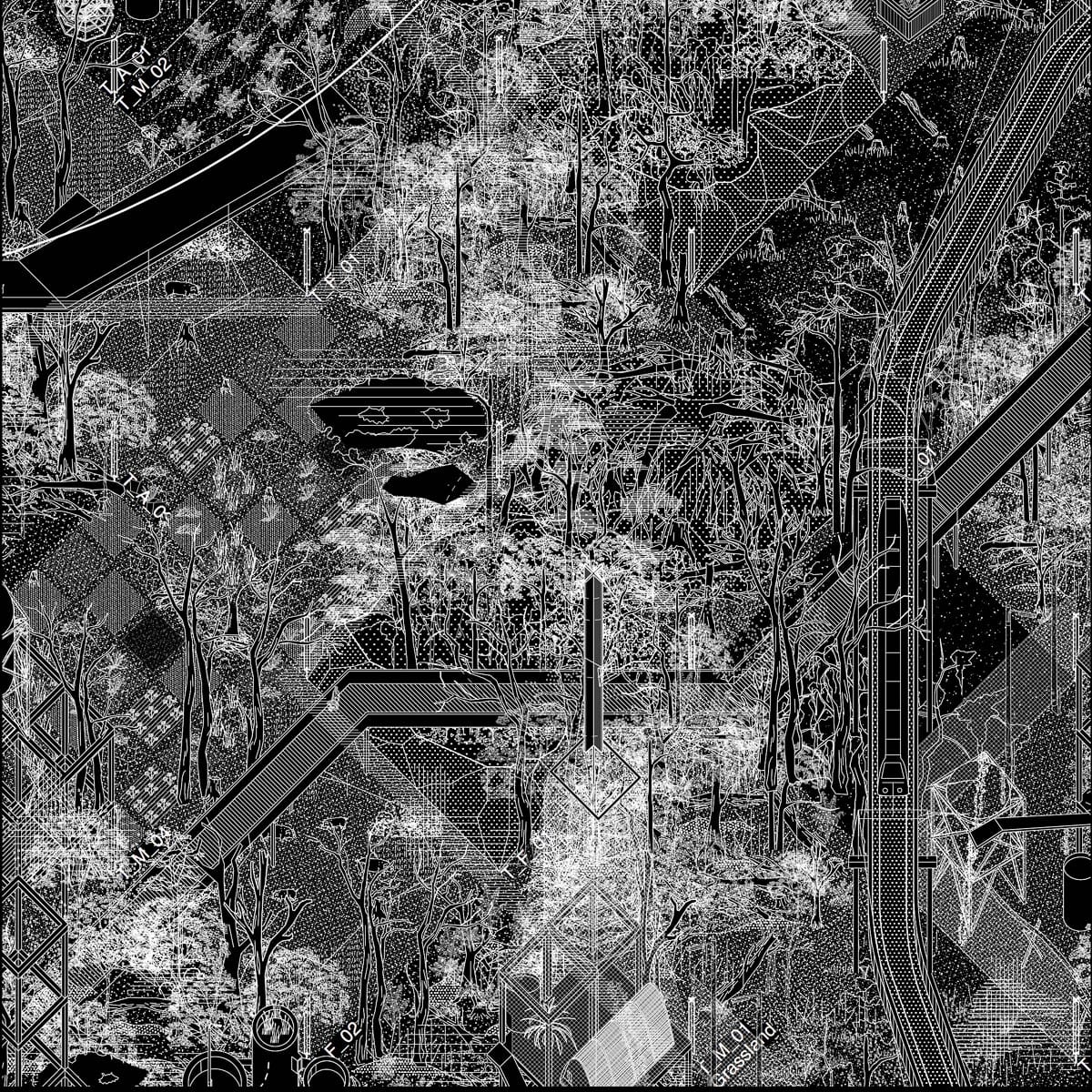
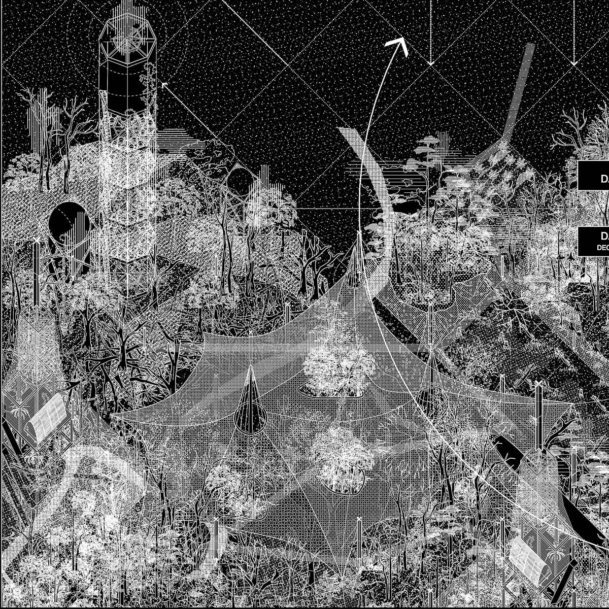
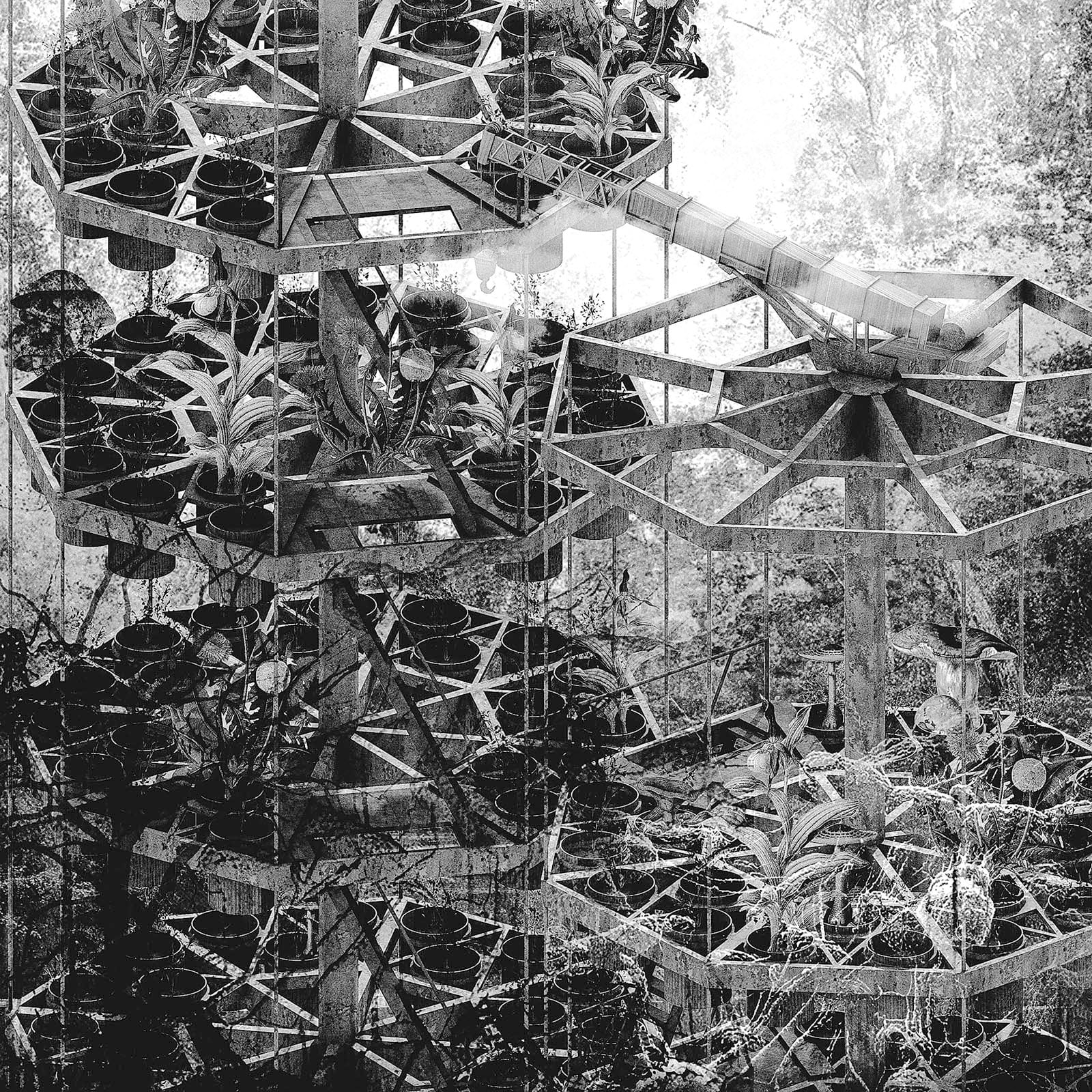
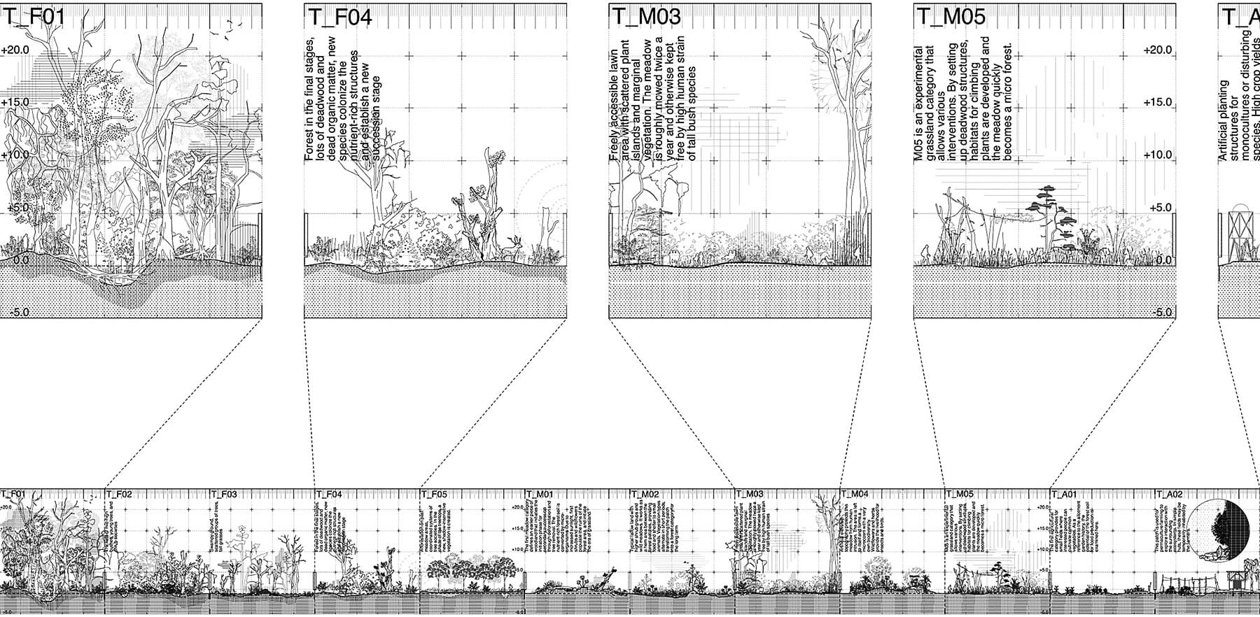
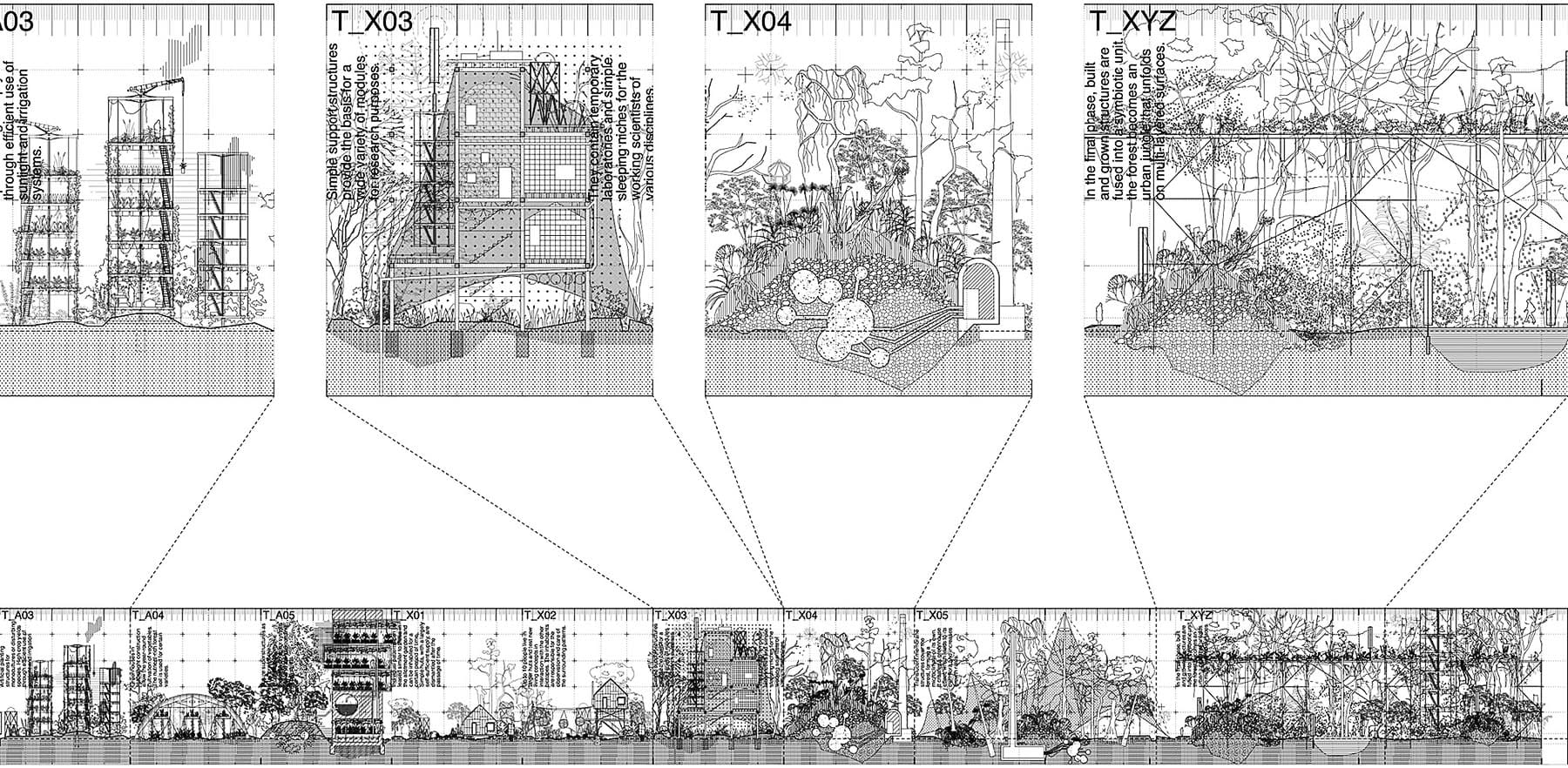
Speculative timeline: The system is in constant change. It starts in a small area and spreads gradually over the years in the environment. Key events are always the initiation of new test fields whose characteristics and structural composition are determined by the algorithm. The theoretical layers of categories, rules and codes are overlapped by the real movement of plant growth, animal distribution and human actions that take place in this area. The development is supposed to increase several parameters like structural density, bio- and agrodiversity, and biomass.
Axonometric patterns simulate a possible structural appearance of different biotope typologies. In their random arrangement, the fragmented landscape can be represented, which, like the built city, contains different functions in different locations. Due to the concentrated juxtaposition of the patches, various border areas and transition zones are created in a confined space, which in turn are populated by specific species as autonomous ecotones. „High reproductive rates enable species to quickly build up populations in transient patches, thus yielding many new dispersers. The dispersal ability of a species and efficient dispersal vectors are both necessary for colonising newly emerging habitats in dynamic landscapes. However, there may be strong interactions between the temporal spectra and spatial correlation of the distur- bance regime and the life history of a species (Amarasekare & Possingham, 2001).“ In the course of time, the organic structure types are extended by anthropogenic structures and agricultural topographies, resulting in an increasing overlapping and networking of different functional and usage requirements. The drawing shows four different time frames of the experiment, from the implementation of the system on the existing site to the auton- omous growth and symbiosis of natural and artificial structures and processes in the end.