

A brief History
of the Ried
from its birth
to its current state
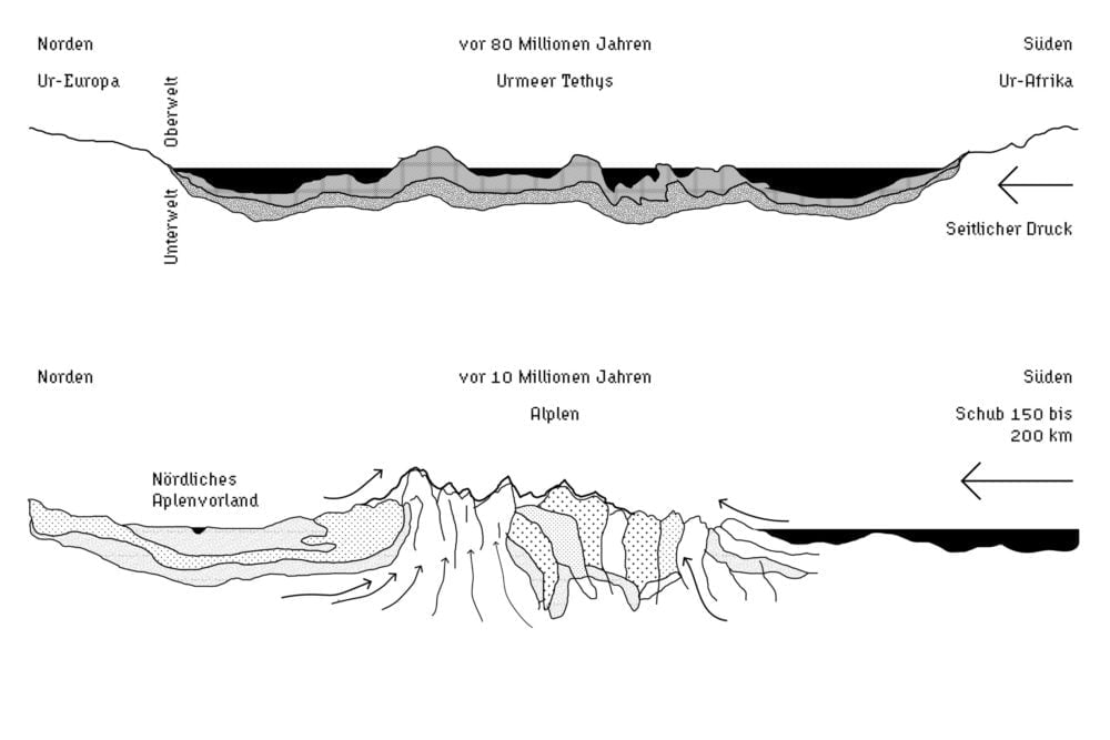
“Als [die Alpen] sich vor etwa 40 bis 50 Millionen Jahren aufzuwölben begannen, um ein Gebirge zu bilden, sank — ebenso unmerklich langsam — das nördliche Alpenvorland in die Tiefe…”1“When [the Alps] began to bulge up to form a mountain range some 40 to 50 million years ago, the northern Alpine foothills sank – just as slowly imperceptibly – the northern foothills of the Alps sank into the depths…” Zier, Lothar. Das Pfrunger Ried. Entstehung und Ökologie eines oberschwäbischen Feuchtgebietes. Zweite Auflage. Stuttgart, 1998. p. 16.
It is strange – the deeper one delves into the past of a landscape, the more its solidity dissolves into the movement of floating lines, and time becomes elastic as it seems to shrink or expand according to different processes. The various stories of a landscape’s individual elements appear as threads of a mineral fabric – a workpiece made of countless steps of production and destruction, not least by man but above all by much more mysterious and deeper forces.
The foreland was flooded, sunken, lifted up, shaped by the ice and washed out by the streams of melting water. After this million-year-long procedure was completed, the necessary conditions for the birth of the Ried were given so that it saw the light of day about 12,000 years ago. In its prehistory, a multitude of geological processes like erosion and sedimentation triggered climatic and biological reactions so that the vegetation continued to prepare and refine the place as an breeding ground for wetlands. As soon as the first people entered the stage of this place, they also became creative actors and introduced the transgression of the moor into a cultural typology: The wilderness was increasingly integrated into abstract systems such as ownership, law, energy consumption and agricultural productivity. This, in turn, directly impacted the wetlands ‘natural’ reality: Each Intervention triggered deep changes in species distribution and biodiversity and, accordingly, also changes in atmospheric conditions, hydrology and the modes of peat production. The accelerated anthropogenic interventions for drainage and melioration in the last two centuries have left only a fraction of the once huge mire area, which has shrunk to the core zone of the valley. Only in recent decades large-scale nature conservation measures have led to a reversal of the trend and allowed the moor to grow again in some areas. The collage on the previous page imagines the creation of the Ursee as the last Glacier retreats leaving a strange sentiment of solitude and vastness in the flooded basin. Another collage shows different modes of peat cutting and earthworks. In a collective approach and with hard physical labour, the Ried is rendered into a three-dimensional collage in its own way.
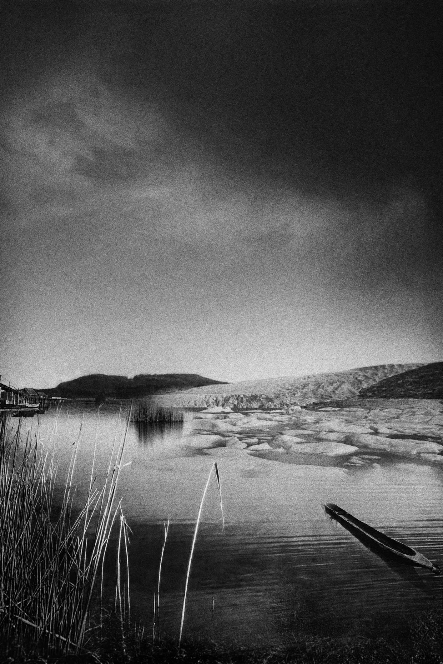
Collage: Imagination of the Ursee.The retreating glacier leaves behind a peculiar landscape and a strange sentiment of solitude in a time so distant from our own.
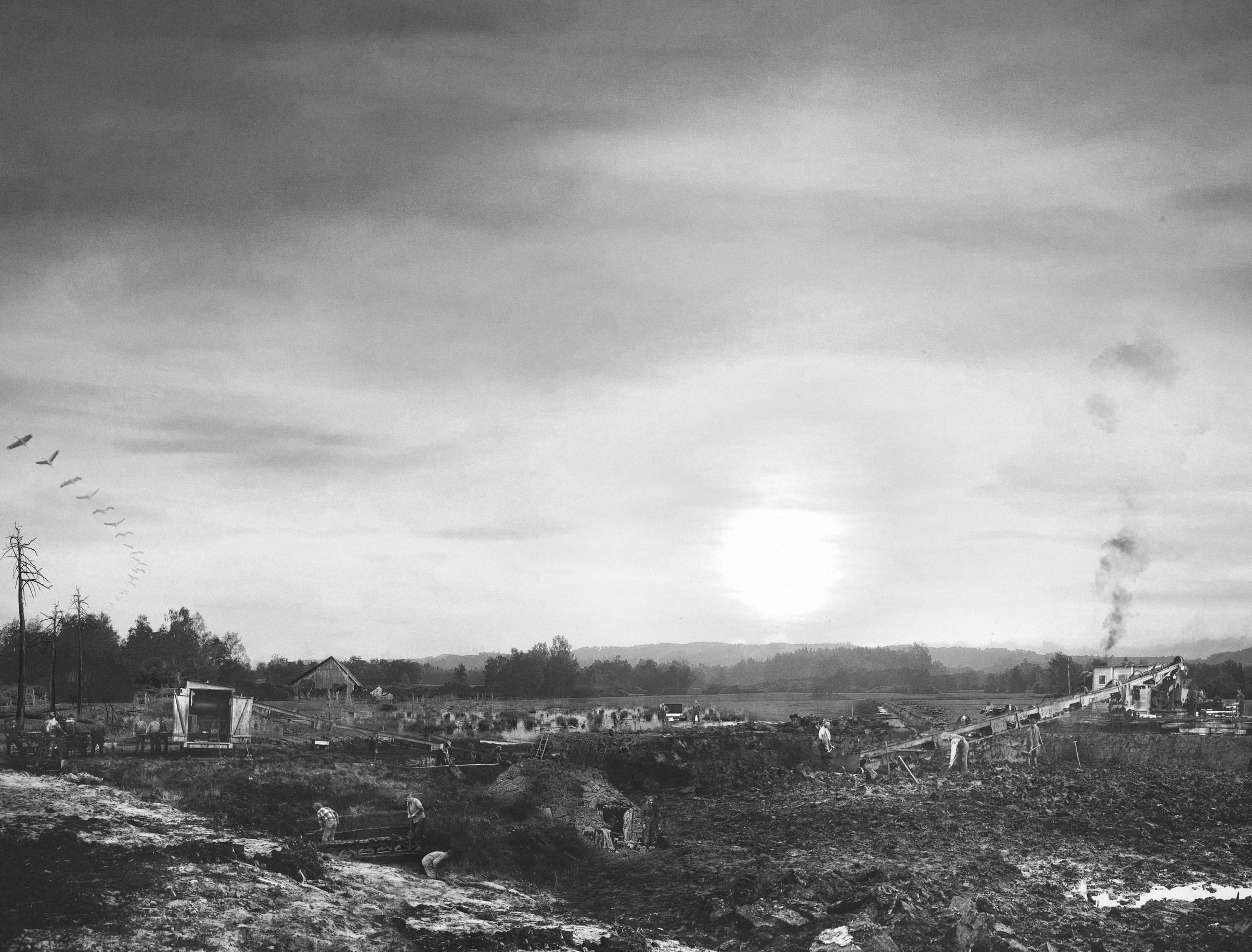
Digital Collage. Landscape transformation through different modes of peat extraction.
From Deep Time and Geology
“The strata of the Earth is a jumbled museum. Embedded in the sediment is a text that contains limits and boundaries which evade the rational order, and social structures which confine art. In order to read the rocks [and the layer of peat] we must become conscious of geologic time, and of the layers of prehistoric material that is entombed in the Earth’s crust.”2Smithson, Robert. in: “Robert Smithson: The collected Writings” Edited By Jack Flam, 1996. p 110.
With the metaphor of earth strata as a museum, Smithson opens up a thought space one could enter to explore and experience scenes of earth history while its narrative depends on a certain format of curation and representation. What objects and events are taken into consideration and put in relation to each other and what graphic language might be suitable for such a speculative museum? How are we related to the items we observe? Supported by the museums’ collection we can imagine the lands’ own origins and stages of life that first seem to be independent of cultural history in terms of its extent and time scales. While in human temporal perception and from an architectural perspective landscape (the ground) is regarded as a rather static canvas or base surface and a scenic backdrop that first gets revived through human development, redesign and usage. But in geologic terms, landscape is a highly fluid and fragile occurrence, that underlies constant movement and reshaping. These fluid mineral bodies further provide temporal fixed areas or time pockets, that allow cultural and ecological processes to emerge within, like the emergence of bogs in the depressions of the foreland. So in order to decipher the narratives of the ground we need to switch between time spans and approach the realm geologic time time since “[…] the need to imagine deep time in light of our present-day concerns is more vital than ever. Deep time is not an abstract, distant prospect, but a spectral presence in the everyday. The irony of the Anthropocene is that we are conjuring ourselves as ghosts that will haunt the very deep future”3Farrier, David. Aeon Magazine: „How the Concept of Deep Time Is Changing“. The Atlantic, 31. Oktober 2016. https://www.theatlantic.com/science/archive/2016/10/aeon-deep-time/505922/
“Deep Time” is a concept first described by the Scottish geologist James Hutton (1726-1797) in 1788, and was later on revived in the essay Basin and Rage by John McPhee, where he elaborates that, “Hutton thought about the earth as it was; and what he did permit his imagination to do was to work its way from the present moment backward and forward through time.”4McPhee, John. Basin and Range. The Noonday Press, New York, 1980/1981. So time seems to be a space one can access and experience through imagination and the creation of certain narratives that consider human characters as well as bodies of earth (bodies of peat, water, ice and minerals) as protagonists. In this sense, the landscape becomes a product of complex histories that slowly materialise in sediments, soils and formations, which in turn set the stage for the stories that follow. This process describes the transition from narrative metaphors and principles into physical bodies and structures and hints at the previously described concept of the Archē. Its linear continuation is reflected in soil strata and earth horizons that we can observe on the break-off edges in rock walls, quarries, gravel pits and peat cuts. These fractures, distortions and rearrangements that compose the materiality and topography of a landscape are thus not only spatial but also narrative phenomena, where retrospectives, anticipations and leaps in time can be traced. With this in mind, we should take a look at what earth bodies once interacted to create the bogs like the Ried, or in regard of storytelling, ask what would be written in the Prologue of this place.
“1st, There is a central body in the globe. This body supports those parts which come to be more immediately exposed to our view, or which may be examined by our sense and observation. […]
2dly, We find a fluid body of water. This, by gravitation, is reduced to a spherical form, and by the centrifugal force of the earth’s rotation, is become oblate. The purpose of this fluid body is essential in the constitution of the world; for, besides affording the means of life and motion to a multifarious race of animals, it is the source of growth and circulation to the organized bodies of this earth, in being the receptacle of the rivers, and the fountain of our vapours.
3dly, We have an irregular body of land raised above the level of the ocean[…]”
In continuation of Hutton’s description we could add here a fourth paragraph describing the hybrid body of wetlands:
4th, We find an amorphous body of peat where land and water submerge, and that we will further describe as bogs…
In the listing of these ‘earth bodies’ we already find the tendency to describe our physical surrounding world with the familiar terminology of the (human) body. So we project our immediate spatial understanding of individual bodily presence and the respective termination on the landscape, transgressing scales and dimensions. Different landscape elements work as the skeleton, skin, blood and organs. Hutton introduces his theory with these body metaphors to describe the globe as a whole: the earth’s core as an inner solid ‘body’, working as a support structure to mount the other parts. The fluid water body (ocean, lakes, rivers, clouds, glaciers, …) that mantels the body and is responsible for the movements and dynamics of the earth system and in general, its ‘liveliness’, and last, the ‘irregular body of land’ (earth landmass) that is inhabitable by human life. If we now zoom in on our “Ried”, we can figure out to what extent these principles’ bodily analogies could be found in the peat body and which earlier forces set the stage on which the history of the moor could take place.

The Amphitheatre
While observing the landscape dynamics on a condensed time scale, one gets the impression that there were no fixed or continuous places but rather snapshots – individual frames in a movie, or if we refer to Foucault’s words that “[…] the place of a thing was only a point in its movement, just as the stillness of a thing was only its infinitely slowed movement”.5Foucault, Michel. Andere Räume. (in: Barck, Karlheinz u.a. (Hg.), Aisthesis. Wahrnehmung heute oder Perspektiven einer anderen Ästhetik, Leipzig 1992, S. 34 – 46). (Own translation) The observed ‘place’ of the Ried is centrally located in the Upper Swabian hill country, a young moraine landscape dating back to the Würm Ice Age, which was formed by the expanding Rhine Glacier 70,000 to 115,000 years ago and was finally rendered during and by the last glacial maximum of the Würm Glacier to its now recognisable topography.6Regierungspräsidium Tübingen (Hrsg.) (2020): Managementplan für das FFH-Gebiet 8122-342 „Pfrunger Ried und Seen bei Illmensee“ und das Vogelschutzgebiet 8022-401 „Pfrunger und Burgweiler Ried“ – bearbeitet von P. Arnold und H. Eberlein. After the retreat of the melting ice masses, and the formative work of the changing meltwater streams, landforms typical of post-glacial disintegration landscapes (Eiszeitliche Zerfallslandschaften) remain as topological pivot points.7Beckenbach, Elena. Geologische Interpretation des hochauflösenden digitalen Geländemodells von Baden-Württemberg. Stuttgart 2016. p. 39. The area is surrounded by Tertiary molasses mountains, which reach their highest elevations in the Rinkenburg (718m above sea level) in the east and the Höchsten (837.8m above sea level) in the west and once acted as flanks between which the glacier drifted into the valley. The first advance of the Würm I glacier reached deep into the basin, filled it with gravel and piled up a terminal moraine (Endmoräne) at the height of Ostrach, which closed the valley to the north. The last advance of the following Würm II glacier, on the other hand, only reached between the flanks of Höchsten and Rinkenburg and closed the valley at its southern end. What remained was a wide valley depression whose water drainage to the north and south was cut off by the terminal moraines of the different glacial intervals. The excess melt water and the turbid matter (glacial milk) contained therein sealed the valley floor through constant subsidence and the formation of a layer of lake chalk – the ideal conditions for the formation of a huge primaeval lake (Ursee), and thus the precursor to the formation of our moor.
Re-emerging Forest Worlds
“When the glaciers of the last ice age began to retreat some ten thousand years ago, lifting the wintry blanket that spread over much of the northern hemisphere, it marked the beginning of a new climatic era that geologists call the Neothermal. The warming trend provoked heavy rainfall. Forests hitherto suppressed by the ice age once again covered the land. Melting glaciers, relentless rainfall, the spread of forests – these concurrent phenomena amounted to an ecological upheaval of cosmic proportions.”8Harrison, Robert Pogue. Forests: The Shadow of Civilisation. The University of Chicago Press, 1992. p 197.
Sometimes shark teeth are found deposited in the Upper Marine Molasses and still bear witness to a time before the land when the primaeval ocean surrounded the Alps. Mammoth teeth (Found in a gravel pit near Ostrach) originating in the Interglacial and horns of aurochs and other fossils embedded in the gravel sediments and peat strata again remind us of a time when huge mammals roamed the (post-)ice-age region. [Zier: 1986]
